Named Places
Douglas County is the eleventh largest county in Missouri, 813.63 square miles, with a population of less than 14,000 with 3,000 of those living within Ava City limits.
Ava is the only incorporated town, so there are markers throughout the county, like Brushyknob, or Sweden, or Denlow, to show what area of the county you are in. Someone will ask Where do you live? And you will tell them, Sweden, or Jackson Mill, and they will know the exact area, they may ask who you bought from, and recount childhood stories of a visit to your house or fishing in your pond. Below is a little history on how these areas got their names. The county maps are in three parts - Western, Central & Eastern.
Ava is the county seat. There is one four-way stop light, and one blinking red light. There is a Walmart, a few fast food restaurants. Like so many small towns in Southern Missouri, there is a mixture of old and new. More employers are needed, but it is also true that those who bring their own skills will find a grateful community. Ava is 40 minutes North of Bull Shoals Lake and Norfork Lake. 45 minutes Southeast from Springfield, 45 minutes East from Branson. Notice distance is in minutes? Rolling winding roads equals minutes not miles.
Ava is called “Treasure of the Ozarks” Come discover the treasures of Douglas County, come discover a place to call home. To visit Ava City Website: http://avamissouri.org/
WESTERN DOUGLAS COUNTY NAMED PLACES
ARNO - Sometime prior to 1857, William J. Turner (1814-1879) moved to the old Indian village site at the mouth of Cowskin Creek which was at that time in Taney County. On February 4, 1857, he established a post office on the site naming it Arno. [White River Valley Historical Journal, Winter 1963-64].
ARDEN - Post office from 1887 to 1923. Named from Shakespeare's Forest of Arden in AS YOU LIKE IT.
AVA - The county seat of Douglas County was named and laid out in 1871 by James Hailey, one of the commissioners appointed for that purpose. He named it Ava from a verse in the Bible (2nd Kings 17:24). In the Hebrew, Ava is said to mean "overthrowing." It may be that Mr. Hailey intended a humorous reference to Ava's ‘overthrowing’ its rival aspirant for the county seat. The story is that the three commissioners, appointed only to lay out the town, one night stole the county records from Vera Cruz, then the courthouse, and brought them to Ava and established the county seat there.
BRYANT - The post office established in 1889, but the area was known as Bryant long before that. Moses C. Miller settled on Bryant River and had a water mill in 1856.
CROSSROADS - Post office in 1907 on the crossroads.
DOGWOOD - Post office established in 1903 and named for the dogwood trees.
DEPEW - Post office established in 1901, named for Senator Depew (1834-1928).
GOODHOPE - Post office from 1895 to 1923; named by J.H. Johnson.
GRANADA - Post office 1895 to 1920, named by C.P. Anderson after the Spanish Granada.
JACKSON MILL – Mill built in 1835 and named for its owner. (Partial remains of the old Mill still set in the creek)
REDBANK - Post office 1892 to 1897, named by William Rhodes because it was on a red bank along the old Salt Road.
ROY - Post office and store in 1890 named for Lafe Roy, the first postmaster, and store owner.
TIGRIS - Post office, in 1921 and named by John Allen, the first postmaster, for the river in Mesopotamia.
MERRITT – Post office in 1903 and named after the first postmaster.
MOUNT ZION – Community of The Church of God (Holiness) that began on March 29,1883, with the founding of a church in Centralia, Missouri with 44 members. Mount Zion has a private Bible School.
ONGO – Post Office 1897 to 1949. Sets on the banks of Swan Creek.
ROME - Post office established before the Civil War and named by Frank Richards after Rome, Italy. Sets on the banks of Beaver Creek. Owned by a local family.
SMALLETT - (earlier Salt Road Post Office) Post office named for its first postmaster, James Small.
WITTY - Post office in 1893 to 1924 named after "old man Witty," the first postmaster.
The above was taken from the archives of the Missouri Historical Society. If you would like to see more named places in Missouri go to https://shsmo.org/manuscripts/ramsay/ramsay.html
CENTRAL DOUGLAS COUNTY NAMED PLACES
The terrain starts to change as you travel East out of Ava. It becomes more hilly, steeper ridges which create larger waterways. Views across the Ozarks from Highway 14 that runs along the ridgetop are spectacular.
Highway 76 East is North of Ava and runs to Willow Springs, is a beautiful drive any time of the year and only adds five minutes to the drive over Highway 60. This Northern part of Douglas County is gently rolling hills and drops into the steeper ridges as you travel South and East. Highway U only runs between Highway A at Mansfield, to Highway 76 East North of Ava. Maybe 15 miles long, there are beautiful family farms and because it is windy and hilly the only ones that use this Highway live out there. Parts of 76 East run along the ridge edge giving you those stunning long range views, and views of Bryant Creek. Then down the ridge to the bottom where it will break out into huge bottom fields. Champion, Highway V dotted with family farms, a short drive to Mountain Grove or Norwood to the North.
Highway VV off Highway 14 will take you down to Hunter Creek. Enormous towering bluffs and county roads wind around, up and down following the waterway. Some of the roads dead end, some will take you out to Highway 76, either way, you’ll be glad you went.
Rippee Conservation Area - Rippee Conservation Area is at the junction of Rippee and Bryant Creeks in central Douglas County. For maps and more information from the Missouri Department of Conservation on the Rippee Conservation Area go here: https://nature.mdc.mo.gov/discover-nature/places/rippee-ca
Aerial Ozarks-Published on Oct 2, 2016
Assumption Abbey – 3000+ Acres with the monastery. The monks first came to Douglas County from Iowa in 1950 to establish the monastic life here. The Abbey does have day use and guest facilities. The Assumption Abbey Website: http://www.assumptionabbey.org/
BASHER - Post office 1909 to 1912, named for Harve Bash.
BERTHA - Post office established in 1904-1909 and named after Bertha Hawkins, daughter of the first postmaster.
BRUSHYKNOB - Post office established in1903 and named for the schoolhouse that was first there.
CHAMPION – Location of a school timeline unknown.
CHENY - Post office established in 1899 by a Mr. Reed and named after A.B. Cheney, an old settler.
COLDSPRING - Post office as early as 1878, named for a spring in the vicinity.
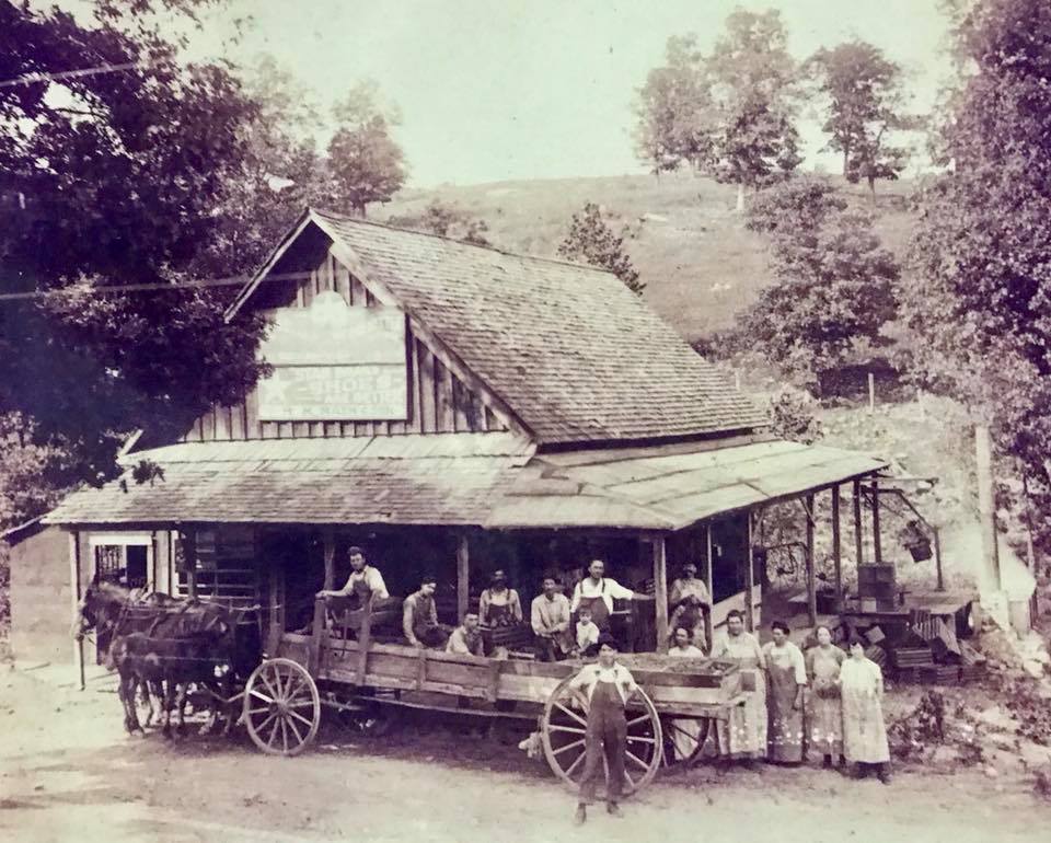
Picture of Tomato Factory at Denlow
DENLOW - (earlier Upshaw) Post office on Fox Creek, in 1896 to
1916.
GIRDNER - Post office established in 1887 and named after "Doc" Girdner.
FIELDEN - Post office in 1894 to 1906-1910, named by John H. Smith, who had one of the first sawmills in the country. He named his mill Fielden because it was one of the few fields which had been cleared at this time.
FILER - Post office discontinued in 1911, was named for the Filer family.
LARISSA - Post office, established in 1889 and discontinued in 1920; named for the wife of the first postmaster.
MIDWAY - This community was half way between Ava and Mansfield. It was the site of a severe storm in March 1938. Again, in 1945, a storm of tornadic proportions demolished the Midway Store.
OLATHE - Post office in 1895 closed around 1904-1910. It was named by J.O. Miller, perhaps for Olathe, Kansas.
SILVERTON - (later Hilo) Post office in 1890and later discontinued. Named by John Patterson, The name was changed to Hilo (q.v.) about 1900.
SQUIRES - Post office in 1889, named for John Squires, who had a store and the post office. Still operating.
SWEDEN - (earlier OliveSprings) Post office in 1899 and by mistake, it was named Sweden.
VERA CRUZ - Town was established before the Civil War, probably during the time of the Mexican War (1846-1849). Named for the city of Vera Cruz in Mexico. Originally named Red Bud. Post Office opened in 1846. You can visit Missouri Department of Conservation for more information on the Vera Cruz Access here: https://nature.mdc.mo.gov/discover-nature/places/vera-cruz-access
EASTERN DOUGLAS COUNTY Named Places
ANN - Post office established in 1899 and discontinued in 1923, named for the daughter of the first postmaster.

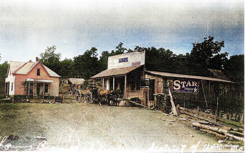
Some people collect baseball cards, others collect coins or stamps or dolls. I collect old photographs. Not even sure where I found this one. Online somewhere (maybe it belongs to you?). Anyway, this is Ann, Missouri, once located just south of Cabool in Douglas County. I haven't been able to find much on it, so maybe some of you can help us out. I love the little slice of 1800s Missouri rural life this shows us, like so many communities during that time period. "Town" then wasn't like "town" now. Since a family was able to produce most everything they needed on the farm, all these little settlements provided was usually postal service and a place to purchase those other necessities, like coffee and salt and sugar. Of course, with better roads, trains and consolidation of schools and post offices, little places like Ann here eventually faded away. ![]()
BUCKHART - Post office 1878 to 1886 and named by J.E. Baker for a big buck deer killed there.
DRURY - Post office established in 1894 and named for the Drury family.
HEBRON Post office in 1904-1910 named for the Biblical Hebron; there was a church organization first.
PRIOR Post office in 1894 by Tom Sherril and named for a neighbor.
TOPAZ - Post office in 1894 by Bart Hutchinson. TOPAZ MILL & SPRING
The Eastern part of Douglas County is the most rural. Combination of some of the most beautiful cattle farms in the county, thousands of acres of Mark Twain National Forest, with the spring-fed Bryant and the North Fork of the White River running through it. A few remote campsites in Mark Twain National Forest but, there are several private campgrounds, float trips, outfitters, to make your visit the perfect get-away.

Blue Ribbon Trout Fishing – Crystal clear spring fed waterways are recorded trout perfect.
Picture: Matthew Taylor and his father Shawn Taylor fish for wild rainbow
and browns in the North Fork of the White River near Tecumseh, MO.
Shannon Ranch Conservation Area This 1,565-acre area is named for the family which farmed it for several years. Ozark glades are found throughout the area. Glades are openings in the woods with rock at or near the surface and a thin soil covering. Unique plants and animals are found on glades. Three campsites, no designated trails. For more information on the Shannon Ranch Conservation Area go Missouri Department of Conservation Website: https://nature.mdc.mo.gov/discover-nature/places/shannon-ranch-ca
Mark Twain National Forest – Thousands of acres of Mark Twain National Forest.
Noblett Lake Campground is Day Use, there are a couple more remote campgrounds. Go to the website: Noblett Lake Campground
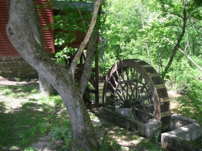 Several year around waterways run through this end of Douglas County. Fox Creek, North Fork of the White River, Indian Creek and Spring Creek. The old grist Topaz Mill is on Spring Creek. Topaz Mill is privately owned and not open to the public.